


Summer is (more or less) here, and area fire agencies are gearing up for the impending fire season.
Banks Fire District volunteers and staff are training for wildfires, and Forest Grove Fire & Rescue is urging area residents to avoid sparking the next wildfire.
In rural areas like Gales Creek, home to farms, small woodlands and plots of land that require clearing, often with the aid of burn piles, a frequent cause of brush and wildfires is escaped burn piles, Forest Grove Fire & Rescue said.
In fact, it’s the most common cause of wildfires in Oregon.
FGF&R said that 54% of reported wildfires in the state were human-caused.
“That percentage is way higher for our corner of the state where lightning rarely occurs,” FGF&R said. “Meaning that humans cause a majority of the fires in our region.”
And with a June 15 open burning deadline set by the state approaching, many landowners are busy torching the season’s burnable detritus before it’s too late.
Burning regulations can be a confusing hodgepodge of regulations based on where you live and if you’re an agricultural or timber operation or not; each jurisdiction may have differing rules, such as if you live within the Oregon Department of Forestry’s protected lands, like Timber or Glenwood residents, or people in some areas in Gales Creek or Buxton.
Or, if a jurisdiction like Banks Fire District temporarily bans burning due to wildfire danger but a neighboring fire agency like Forest Grove Fire & Rescue doesn’t, one person can legally light that burn pile while their next-door neighbor would be disallowed from doing the same.
That’s not a hypothetical situation; during a spike in temperature three weeks ago, Banks Fire opted to ban burning; Forest Grove Fire & Rescue—which also includes those areas in and near Gales Creek in the Forest Grove Rural Fire Protection District—did not.
Such an occurrence could mean neighbors in places like the Hayward community, which straddles the border between the two fire districts, do not share the same burning requirements at any given time.
A quick way to find out what the burning regulations are in your area is to call your local fire agency.
Regional resources include smkmgt.com/burn.php, which lists current DEQ burning regulations for the upper Willamette Valley.
Banks Fire District
www.banksfire.org/burning
503-324-6262 option 5
Banks, Timber, Buxton, Manning, parts of Montaindale, Roy, Hayward
Forest Grove Fire & Rescue/Forest Grove Rural Fire Protection District
https://www.forestgrove-or.gov/fire/page/open-burning-information
503-992-3240
*Gales Creek, Glenwood, areas on the southern portion of Timber Road, Hillside, Watts, rural areas around Forest Grove
Tualatin Valley Fire & Rescue
www.tvfr.com
Burning map
Open burning line: 503-259-1789
General number: 503-649-8577
Portions of Roy and Mountaindale and some areas to the east of Banks
Oregon Department of Forestry Forest Grove District
www.oregon.gov/odf/fire/Pages/restrictions.aspx
503-357-2191
Areas close to the Tillamook State Forest, Glenwood, Timber, areas just outside Gales Creek Valley confines, Tophill, parts of Buxton, Manning, and more.
Fire safety tips
There’s no word yet on when area fire agencies like the local office of the Oregon Department of Forestry will declare fire season has started; elsewhere in the state, Jackson and Josephine County’s fire season began June 1.
FGF&R advised the following safety tips when burning.
-Maintain at least 10ft of bare dirt around the pile to prevent flames or sparks from starting a fire. -Keep a shovel and water source ready at all times. -Never leave a burn pile unattended. -Once done, make sure the fire is out and the ashes are cold to the touch. -Please be aware of weather conditions. Even if you’re allowed to burn, it’s recommended to not burn during dry and windy conditions.
And for those traveling in forested areas, the agency urged these common sense tips
-If you’re towing a trailer, secure your trailer safety chains so they don’t touch the ground. If they can touch the ground, they can create sparks that can cause fires on the shoulder of the road. -Don’t drive or park on tall grass or vegetation. The heat from your engine and exhaust system can catch the vegetation on fire, without being noticed if you’re driving through. If parked, your vehicle could also catch on fire. -If you’re wanting to have a campfire, check local restrictions first, different forests have different rules throughout the state. Use established fire pits, and once started, never leave them unattended. Once you’re done with the fire, make sure it is completely extinguished and ground is cool to the touch.
Prepare to evacuate
If a wildfire does spark and area homes are in danger, the Oregon Department of Emergency Management said residents should heed Oregon’s color coded evacuation system.
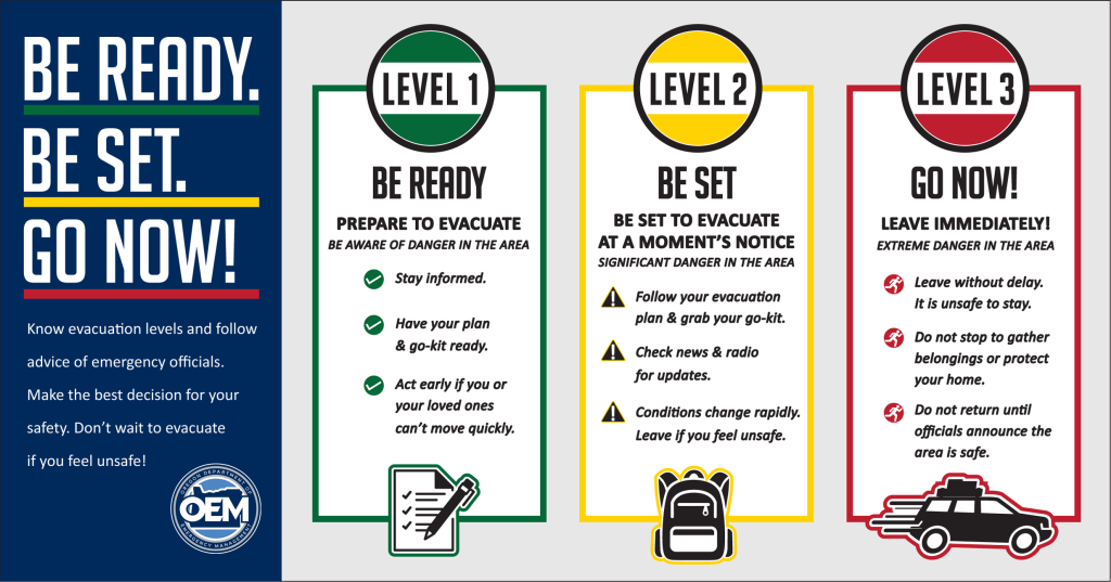
*-Level One (colored green on a map) means “BE READY” to evacuate. Community members should be aware of the danger in their area and stay informed. Check county, city and emergency services websites and local news for information. This is the time to pack and prepare to leave. Check with loved ones and emergency contacts. Reach out to neighbors, share information and ask for help if needed. Some people should consider leaving early if they can’t move quickly and need more time to evacuate, including older adults, families with children, people with disabilities, livestock and pet owners, and those with limited access to transportation.
-Level Two (colored yellow on a map) means “BE SET” to evacuate. This level indicates there’s significant danger in the area and community members should be prepared to leave at a moment’s notice. Voluntary evacuation at Level Two is recommended, especially if people need extra time or have livestock to move. Be prepared to relocate to a shelter or with family or friends outside of the affected area. Don’t wait for another evacuation notice if it doesn’t feel safe to stay.
-Level Three (colored red on a map) means “GO.” Leave immediately! This level indicates there’s extreme danger in the area and it’s unsafe to stay. Emergency services may not be available to offer further assistance to those who choose to stay. People should not stop to gather their belongings or make any efforts to protect their homes or shelter. Leave without delay.*
Once evacuated, residents should stay away until local officials have said it’s safe to return.
Banks Fire trains for wildfire
Volunteers and staff with Banks Fire District conducted wildfire training exercises two Monday drill nights in a row, Banks Fire District spokesperson Mitch Ward said.
On May 22, fire crews worked in a recently logged area for their drills.
“We used standard progressive hose lays for mock flame suppression,” Ward explained. “Hose lays can stretch miles long. Water is pumped from the brush rigs (off road fire trucks), and those brush rigs were kept full by water tenders. Water tenders shuttle water from a source (hydrant or creek) and supply the brush rigs.”
Crews also practiced safety measures firefighters must take to stay alive while undertaking the dangerous work of wildfire fighting, with drills including understanding escape routes, safe zones, and emergency fire shelter deployment, Ward said.

Chas Hundley is the editor of the Banks Post and sister news publications the Gales Creek Journal and the Salmonberry Magazine. He grew up in Gales Creek and has a cat.