Editor’s note: I am turning this into a “Live Blog” style story. The most recent updates will be posted here starting at the top. Major updates like evacuation notices will be noted here and in separate links.
Final update: Highway 26 has reopened, according to the Oregon Department of Transportation.
Update, 5 p.m.: The Banks Fire District sent their thanks to the numerous fire agencies that assisted in today’s fire, noting that while the blaze continued, it was contained.
Crews would remain on scene into the evening, with the highway remaining closed until crews were gone.
“We would like to thank the entire community for their assistance. The local restaurants, the City of Banks, and the community as a whole has been effected and that does not go without notice,” said Banks Fire PIO Scott Adams.
“Although several families lost their homes, and our hearts go out to them, with everyone’s help we were able to contain this fire to those losses and did not need to extend beyond the Level 1 Get Ready evacuation order,” he said.
Banks Fire District 13 would like to extend our greatest appreciation to our partner agencies assisting today on the Hwy 26 Hwy 47 fire. This Residential fire turned Wildland fire began at approximately 9:40am and we immediately began ordering resources from our partner agencies. The fire is contained but still burning and crews will be on scene into the evening. The highway will remain closed with detours while crews are on scene.
Update 3:59 p.m.: The Banks Fire District said around 3:45 p.m. that all evacuation orders were lifted.
Update, 3:35 p.m.: Photos from the scene courtesy Banks Fire District


Update, 3:15 p.m.: Banks Fire District said around 2 p.m. that a small break in the winds had allowed crews to stop the forward progress of the fire and begin to build containment lines around the fire.
“Fire operations will continue throughout the afternoon and into the evening,” Banks Fire PIO Scott Adams said.
Update, 2 p.m.: The Red Flag Warning issued Friday by the Portland office of the National Weather Service begins now. It will be in effect until 8 p.m.

UPDATE, 1:56 p.m.: The bottom half of the innermost circle is currently under a Level 1 evacuation notice.
“All residents between Chrysler Rd., Elk Mountain Rd. and Sell Rd. South and East of the fire should consider themselves in Level 1,” Banks Fire’s Scott Adams said.
UPDATE 12:52 p.m.: The Banks Vernonia State Trail is closing near the fire.
“State parks staff is aware of the situation and they are in the process of closing the Banks trailhead and the Banks-Vernonia State Trail from Banks to Buxton,” said Friends of Stub Stewart State Park and Banks-Vernonia Rails to Trails President Marsha Kirk in a message to the Banks Post.
Kirk added later that the Manning Trailhead would also be closed.
UPDATE 12:40 p.m.: The city of Banks said that water customers outside city limits north of Highway 26 would need to boil their water for the time being due to the wildfire burning near Manning.
“Due to high water demand, the City is unable to meet the required contact time for disinfection of drinking water,” the city said in an email.
“The water is being drawn from the hydrants faster than it can be safely chlorinated,” the city added.
Customers affected were being notified via door hanger and phone of the issue, and are expected to be notified when the boil water notice is issued.
UPDATE: Banks Fire has issued a Level 1 evacuation for a one mile area south and east of the fire at the Highway 26 Highway 47 Banks turnoff. Read the story here.
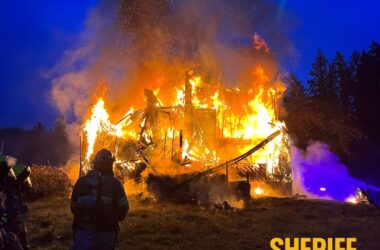
A residential fire broke out near Manning Saturday morning, the Banks Fire District said, with crews responding to reports that a structure was burning near Jim Dandy Farm Market.
At 11 a.m., the district said the fire now included a home, a mobile home, and adjoining wildland.
The Banks Fire District described the area as near the turn off to Banks at the intersection of Highway 47 and Highway 26.
Impacts to traffic on Highway 26 were to be expected, Banks Fire spokesperson Scott Adams said.
“Please avoid the area if at all possible and expect brief lane or entire highway closures,” Adams said.
As of 10:30 a.m., the Oregon Department of Transportation listed Highway 26 closed on tripcheck.com.
At 11 a.m., Adams released additional information, noting that the highway closure would be significant.
“The fire has spread through a mobile home, a residence and there are some spot fires in the wild land area,” he added.
“With heavy winds entering the area by noon we are requesting an additional wild land Task Force to fight the wild land fires that have spun off from this fire,” Adams said.


All residents were believed to be out of the structure with some minor injuries reported, Adams added. He later noted that several “civilians” were injured.
“Significant factors including tight access, power lines down, limited water and the weather will affect the ability to fight this fire,” Adams noted.
A Red Flag Warning for the area takes effect at 2 p.m. Saturday.
Banks Fire is being assisted by numerous area fire and law enforcement agencies, including Forest Grove Fire & Rescue, the Oregon Department of Forestry, the Cornelius Fire Department, Tualatin Valley Fire & Rescue, Hillsboro Fire & Rescue, the Vernonia Rural Fire Protection District, the Oregon Department of Transportation, the Washington County Sheriff’s Office, and Metro West Ambulance.
This is a developing story with limited confirmed information. Story will be updated as we are able to confirm information.
Story updated with additional 11 a.m. update from Banks Fire.

Chas Hundley is the editor of the Banks Post and sister news publications the Gales Creek Journal and the Salmonberry Magazine. He grew up in Gales Creek and has a cat.


