

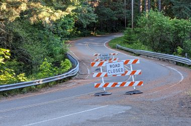
It’s been seven months since Washington County Land Use and Transportation closed Timber Road due to the ground beneath the roadway beginning to give out.
In the time since, the county has hired a contractor to conduct a geotechnical analysis of the slide area and come up with some potential solutions. County staff have conducted meetings and looked at what comes next.
A series of documents obtained through a public records request and emailed from county staff to the Banks Post reveal what the future could hold for one half of the only paved road into and out of Timber.
It’s important to note that the county, which received the technical documents in the last half of September, has yet to make a final decision on repairs and mitigation, and doesn’t currently have funding for most of the options outlined in the following story.
The landslide

The entire northern Coast Range is a hotbed of active geological movement. Landslides in the region are common; so frequent, in fact, that the Oregon Department of Transportation has a sign on Highway 6 in Gales Creek just a few miles from the slide that can be lit to warn motorists of possible landslides in the Highway 6 corridor.
In the 12 months leading up to the closure, three other landslides had occurred in nearly the exact same spot, but these were small slides of dirt and debris from an upper hillside falling into the roadway. All were quickly cleared. The real problem, however, was a known issue: The ground beneath the roadway has been giving out for years.
Those who drive the road know the spot; near the S curves between Timber and Glenwood, the roadway becomes rough, the asphalt patched, repatched, and patched again.
In an email to the Banks Post, Washington County Land Use and Transportation spokesperson Chris Lueneburg explained that what has held the road together until now is a method of repair called “blade patching.”
Lueneburg said the process involves laying hot mix asphalt concrete over deteriorated pavement and then compacted, often with the blade of a motor grader, hence “blade patching.”
“That’s the method we used to repair smaller pavement displacement at the landslide site before March, when the landslide worsened,” he said.
According to documents created by at the behest of Washington County LUT by contractor Cornforth Consultants, the county estimated that asphalt thickness in the patched areas could be several feet or more thanks to the frequent patching jobs done in the past.
“[Washington County] has observed that landslide movement generally increases in the wet winter and spring seasons,” the document reads.
When groundwater levels are higher and heavier rains fall, landslide activity increases.
Recent logging in the area cleared the tree canopy in the slide area as well, “allowing for an increase rate of infiltration,” the documents read.
Heavy precipitation in early 2023 likely contributed to the issue, and it all came to a head March 6.

“Timber Road is closed indefinitely between Strassel and Cochran roads, due to slow-moving landslide activity,” the county said in a press release at the time.
Cracks in the pavement, noticed by county staff in January, had suddenly worsened as snow melted in the Timber area.
This time, there would be no quick reopening.
What’s next

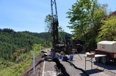
Since then, the county hired Tigard-based Cornforth Consultants to perform a geotechnical analysis of the site and come up with initial options for a repair, a process that yielded several documents outlining the issue and three landslide mitigation options the county could pursue.
The documents themselves are packed with details about the slide and the possible options. Read them here. and here.
In an email conversation with Lueneburg, he said the initial geotechnical work was to define the shape, location, and movement of the landslide. With that information in hand, the county’s contractors developed three possible project concepts to stabilize the slide.
“Each of the options has advantages and disadvantages. Our staff are working to weigh the costs and benefits of the project concepts,” Lueneburg said.
Here’s a summary of the three landslide mitigation options. We’re calling them options A, B, and C.
Options A and B are both what are called “shear key” concepts to mitigate the landslide.
“A shear key would involve excavating soft earth under the landslide down to the stable ground and replacing it with a stronger rockfill to improve stability,” Lueneburg said.
Option A: Shear key at roadway and embankment reconstruction

This option would replace earth under the road and in the embankment below the slide, with an estimated cost—for now—of $3.5 to $4.5 million.
“Costs may escalate due to rising material and construction expenses or other unforeseen circumstances,” Lueneburg cautioned.
The contractor listed a number of advantages and disadvantages for the concept; one challenge would be that the plan would likely require the county to acquire additional right-of-way from adjacent property.
As of a September 22 meeting, this was the county’s preferred option “for now,” according to meeting minutes.
“This alternative would remove the incompetent material beneath the existing roadway and widen and repave the roadway to allow for guardrail installation,” the minutes read.
Option B: Shear key below the roadway

This option would replace earth entirely in the downslope embankment, with an estimated cost of $2.5 – $3.5 million.
One disadvantage listed noted that this option wouldn’t replace the soft embankment and slide debris directly beneath the road itself.
And then there’s option C: a Mechanically Stabilized Earth (MSE) wall.

This option, with an estimated price tag of $3.5 to $4.5 million, “would involve excavating the earth directly under the road, down to stable ground. It would be replaced with stronger fill materials supported by a retaining wall on the outer edge of the road,”Lueneburg explained.
What about a temporary option to get the roadway open while awaiting a more permenent fix?
It may be a difficult, even dangerous task to get a temporary fix in place, Lueneburg said. The county is still considering options for potential interim repair options.
“Basic pavement repair (like blade-patching) would not improve slope stability and could create serious risks for travelers,” he said. “Landslide movement is unpredictable, especially during the rainy season, and substantial pavement displacement can happen over short periods of time– as was evident in March when we decided to close the road,” he added.
More significant temporary fixes would come in around $1 million dollars, wouldn’t address the slide issue on a long-term basis, and would end up being destroyed when a more permanent fix is in place.
Here are some of the options the county and their contractors discussed during a Sept. 22 meeting to discuss the Timber Road landslide repair mitigation options and concepts.
Re-leveling and repairing the asphalt at the landslide site—similar to earlier repairs there—could get the road open, but would require continued repair as ground movement could continue to occur, especially in the winter.
Another option would be to install a trench drain at a depth of about 10 to 15 to improve groundwater drainage throughout the slide area. Groundwater is believed to be a contributing factor to the current instability of the slide area.
A third option would be a “deep patch,” an approach that would require a five foot thick zone of geogrid—a type of metal mesh used to reinforce earth and retaining walls and provide stability—reinforcement layers within aggregate base rockfill.
“The deep patch does not significantly increase the overall landslide stability,” a preliminary memo read.
Any of these options would likely mean county staff monitoring the site weekly, with additional monitoring as frequent as every day needed during wet weather events, and an evaluation to see if changes to signage would be needed. If the landslide activity continues to increase, a mitigation concept reads, temporary traffic signals could be used to control a single-lane road to route travelers around the slide.
What about building a new Timber Road elsewhere?
It’s not in the cards.
“We don’t have any right-of-way in the area outside of the road’s current path,” Lueneburg said. “Acquiring right-of-way and building a new roadway would be prohibitively expensive.”
What’s next?

A rough timeline, which has not been formally announced or adopted, showed that the county could submit a grant to the Federal Emergency Management Agency’s (FEMA) Building Resilient Infrastructure and Communities Grant program by December 2023.
If awarded, a possible interim repair could be in place in 2024, with the ultimate landslide mitigation repair possible in 2024 or 2025, but the timeline held question marks for when those repairs could start.

Chas Hundley is the editor of the Banks Post and sister news publications the Gales Creek Journal and the Salmonberry Magazine. He grew up in Gales Creek and has a cat.