

Seven people died in crashes in 2021 on the Wilson River Highway, stretching from just east of Banks, through Gales Creek, Glenwood, and Lees Camp before ending in Tillamook. An open house examining potential solutions to safety problems on Highway 6 is open until May 26.
The Oregon Department of Transportation produced the online open house as it draws close to delivering a full report on the state of Highway 6.
House Bill 4053, introduced by then-State Rep. Suzanne Weber (R-Tillamook) as chief sponsor while she was a state representative serving Gales Creek, Banks, and the North Coast in 2022, was sponsored by Weber following an especially deadly year on Highway 6.
State Sen. Rachel Armitage later joined Weber as a Chief Sponsor, and the bill gained support from a number of other legislators who signed on as sponsors.
The bill directs ODOT to study the highway, and prepare a report including the current condition of the highway, information on deficiencies on the highway, department recommendations to improve the highway’s condition to a state of good repair, a cost estimate for the improvements, and any other pertinent information.

According to the text of the bill, ODOT has until no later than September 15, 2023 to deliver the report to the legislature’s Joint Committee on Transportation.
In 2021, a string of high-profile traffic crashes on the Wilson River Highway resulted in numerous fatalities and public outcry over the safety of the highway. According to ODOT data, seven people died on the highway in 2021. Local residents on both sides of the coast range have expressed dismay at the deaths that have occurred on the highway, which, when they occur, usually result in hours-long closures of the route linking Tillamook and Washington Counties and the wider Portland Metro area to the Oregon Coast.
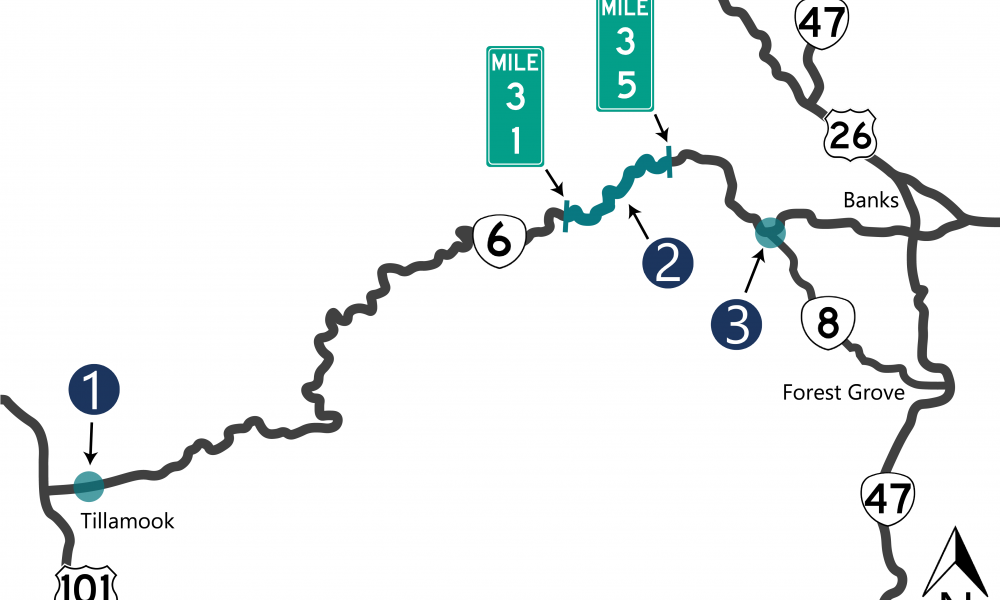
Here’s three of the most problematic areas on the highway linking Banks, Gales Creek, Glenwood, Lees Camp, and Tillamook.
CLICK HERE TO JUMP DIRECTLY TO MILEPOST 2 TO 2.1
CLICK HERE TO JUMP DIRECTLY TO MILEPOST 31 to 35
CLICK HERE TO JUMP DIRECTLY TO GALES CREEK ROAD JUNCTION
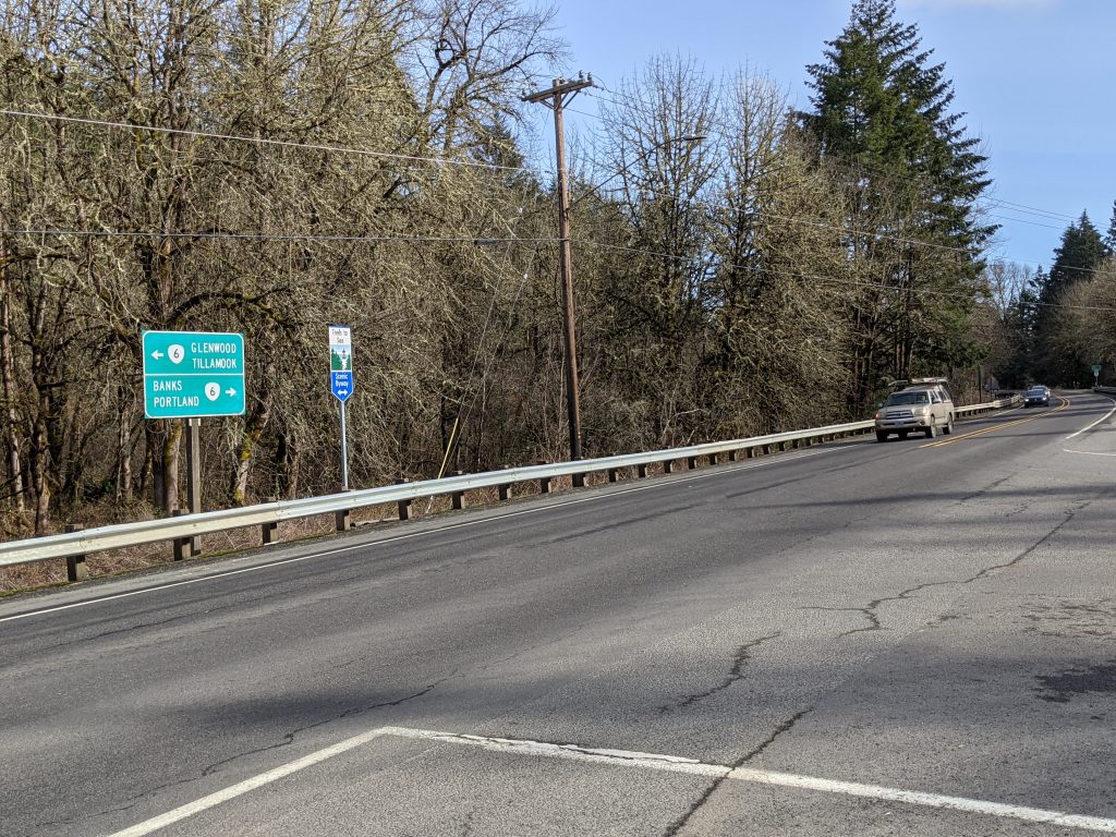
Wilson River Loop East Intersection, milepost 2 to 2.1
Between 2016 and 2020, this stretch of highway just outside of Tillamook saw 15 crashes reported to ODOT.
Of these, 14 involved a vehicle turning. One crash saw severe injuries as a result.
ODOT said the intersection here has a number of issues, including a weigh station east of the intersection where semi trucks merge onto the highway as other vehicles slow to turn right. Additionally, vehicles in the westbound right turn lane block the view for drivers trying to make a southbound turn.
Possible solutions
One solution, ODOT said, would be to modify the existing right-turn lane, and this is in fact a project the highway department is already undertaking, with work currently in the design stage.
The plan is to create a 12 foot buffer between westbound traffic and the right turn lane.
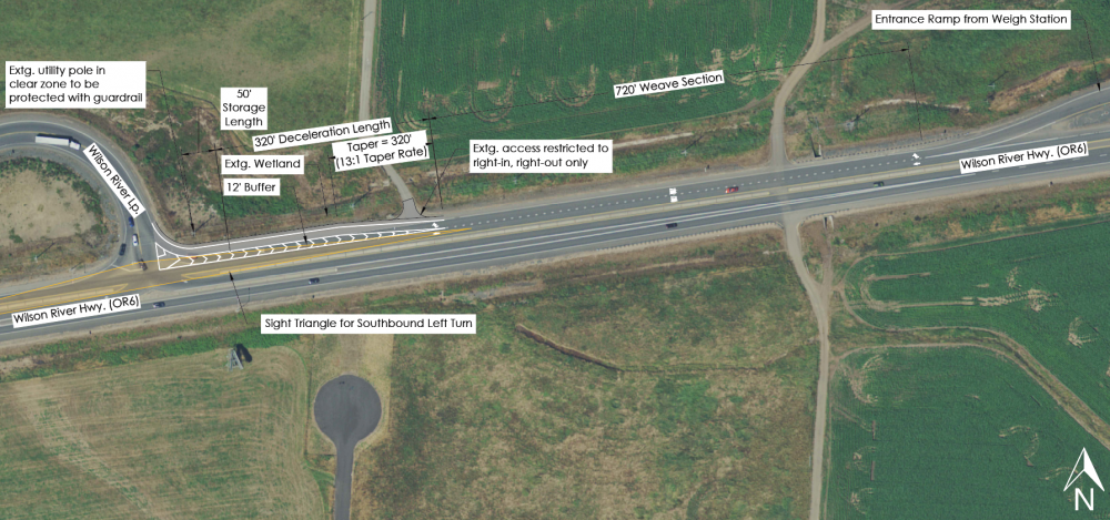
“This will improve sight distance so drivers on Wilson River Loop can see past westbound OR 6 drivers turning right on Wilson River Loop. The buffered right-turn lane will also make travel paths more distinct for drivers wanting to turn left onto Wilson River Loop,” ODOT outlined.
The project is estimated to cost $727,550.
Solution 2: A roundabout
A roundabout in that area of the highway—ODOT listed two possible locations—would reduce injury crashes and slow speeds. It would also require figuring out how to work around the weigh station there, ODOT said, costing additional time and money. The price tag could range from $7.8 to $9.8 million.
“The current project helps address the types of crashes being reported at this intersection,” ODOT said.
Milepost 31 to 35
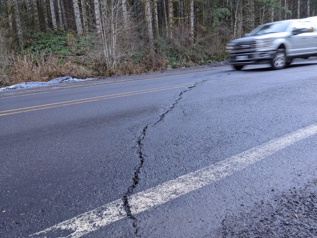
This stretch of highway straddles the Tillamook and Washington County lines, includes the summit of the coast range, and is in terrible condition.
The road threatens to wrest control of your steering as you travel over the cracked, crumbling surface.
Add to that the dangers of ice, blind curves, high speeds, lack of cell service and more, it’s no wonder this area has been dubbed “Danger Mountain” by some regular commuters of Highway 6.
It’s here that some of the worst crashes occur.
“This section had the highest number of severe crashes in the corridor, often between mileposts 33 and 34,” ODOT said. That’s on the east slope of the coast range in Washington County.
From 2016 to 2020—which, it should be noted, does not include the additional fatal crashes in 2021 and 2022—ODOT received reports of 65 crashes between MP 31 and 35.
Seven of the crashes included fatal or severe injuries. Almost half—45%—occurred in icy or snowy conditions.
Twelve crashes were head-on or sideswipe crashes. 18% were on wet pavement. 37 happened in the dark or during dawn or dusk periods.
The mountain itself seems to fight the encroachment of the road on its unstable surface, with landslides such a frequent danger that ODOT maintains a lighted sign near Banks that blinks when landslide danger is high.
Add to this short passing lanes that don’t meet current safety standards, ODOT said.
Possible solutions
ODOT listed several improvements that could be added to the region, and noted their installment of new curve warning signs in early 2022 and an unstable slope review.
“We found how much it would cost to repair and maintain and created a prioritized list for repairs,” ODOT said. That list wasn’t included as part of the open house, but this newspaper has filed a public records request to obtain it.
Improvements that could be undertaken include the installment of delineators and recessed pavement markers to better mark the approach of a curve, replacing the rough pavement with material better suited to wet conditions. The settled roads could be corrected and pavement reinforced, and a review at milepost 30.5 on the Tillamook County side could be done to see if drainage could be improved there.
“All of these improvements would make the area more visible, so drivers will better know what to expect and can slow down,” ODOT said. No cost estimate was available for these projects.
ODOT already has a sign to warn of possible landsides. A similar project could add a weather warning system to warn drivers that the pass is covered in snow and ice.
ODOT could also remove or extend the short passing lanes.
“By modifying the passing lanes we’d help prevent higher speeds and quick merges,” ODOT claimed. ODOT could also look at intersections with roads that enter the highway.
Costs here would vary, ODOT said, and didn’t provide a dollar amount.
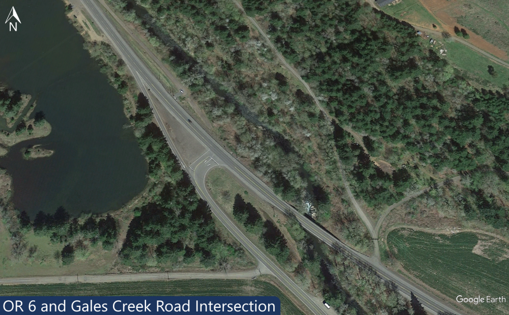
Gales Creek Road intersection
Gales Creek Road intersection
Above: The Gales Creek Road and Wilson River Highway junction on February 24, 2021. Photo: Chas Hundley
ODOT said they received reports of eight crashes at the intersection of Highways 6 and 8—the Wilson River Highway and Gales Creek Road—from 2016 to 2020.
“There have been more crashes than we’d expect for this type of intersection,” the agency said.
None of those reported crashes had serious injuries or fatalities, ODOT said.
Five of the crashes involved a left turn; of these, four were northbound left turns, and one was an eastbound left turn.
Half of the eight crashes were on wet pavement.
“Based on the existing and projected traffic volume, there’s a need for a westbound left turn lane,” ODOT said, but noted a series of obstacles that would make new construction challenging – and costly.
The intersection is sandwiched between two bodies of water. Dorman Pond abuts both Highway 6 and the highway 8 exit lane to the west, while a bridge carries Highway 6 over the waters of Gales Creek just to the east.
ODOT also said that the distance a driver can see is limited at the intersection, which also presents a challenge.
Possible solutions

Solution one: Lots of signs and delineators
ODOT said one approach would be to install delineators—posts, barriers, flexible plastic posts and the like—at the intersection, improve intersection warning signs and striping, put warning signs further in advance of the intersection, install wider six-inch striping with recessed pavement markers and clear vegetation for added visibility.
“All of these improvements would make the intersection more visible, so drivers will better know what to expect and can slow down,” ODOT said.
A cost estimate wasn’t available for such a project.
Solution two: Redesign the intersection
This would be a much more involved solution. ODOT listed several approaches: Gales Creek Road would be realigned, moving it east, slightly closer to Gales Creek and allowing for an eastbound turn lane to be added on Highway 6.
An intersection warning system could be installed to warn drivers of stopped traffic on Highway 6 waiting to turn on Gales Creek Road (and vice-versa).
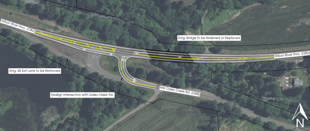
“All of these improvements could help reduce crashes at the intersection,” ODOT said, at an estimated cost of $14.2 million.
The rest of the highway
ODOT also listed a number of other issues throughout the highway.
They include poor signage at recreation sites like the Gales Creek Campground, causing drivers to to slow down or make sudden turns.
ODOT listed ideas for tackling dangerous curves in the road, passing lanes, and poor road conditions and landslides.
“We’re working on stabilizing an active slide at milepoint 34.8,” ODOT noted.
To repair the agency’s 18 highest priority unstable slope sites would cost an estimated $38 million. To repair all of the unstable slopes in the Highway 6 corridor could run the state $114.8 million.
Lack of cell phone access and risky driver behavior were also noted as concerns.
“If more fiber communications are installed along the corridor, we’d have the tools to be able to add more warning system solutions we’ve outlined for other issues along the corridor,” ODOT said.

Chas Hundley is the editor of the Banks Post and sister news publications the Gales Creek Journal and the Salmonberry Magazine. He grew up in Gales Creek and has a cat.