

7:45 a.m. Saturday update: The National Weather Service has rescinded the Fire Weather Watch and replaced it with a Red Flag Warning beginning at 2 p.m. Saturday.
A Fire Weather Watch—often a precursor to the more severe Red Flag Warning—was issued Friday afternoon by the Portland office of the National Weather Service for Saturday beginning at 11 a.m. through 9 p.m.
“Offshore flow is beginning to develop across Southwest Washington and Northwest Oregon today, which will eventually bring hot and very dry air into the region for the weekend. North to northeast winds will increase Saturday afternoon, turning more easterly Saturday night and Sunday. Thermal low pressure will build over the Willamette Valley and Cascades Saturday, and will enhance instability while crossing back over the Cascades on Sunday,” the NWS said in their watch text.
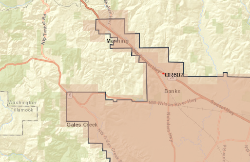
The area in effect for the Watch ends just past the junction of Highway 6 & 8 in Gales Creek, and just past Buxton on Highway 26 for the greater Banks region, and extends all the way east to the crest of the Cascades.
North winds of 10 to 15 mph with gusts up to 25 mph, a relative humidity as low as 15%, and forecasted highs in the 90s combined could create conditions “favorable for rapid fire spread which may threaten life and property,” the NWS said.
“Use extra caution with potential ignition sources, especially in grassy areas,” Forest Grove Fire & Rescue said in a social media post. “Please avoid recreational fires and cooking outdoors if possible.”
A Fire Weather Watch means that critical fire weather conditions are forecast to occur. Listen for later forecasts and possible Red Flag Warnings.

Chas Hundley is the editor of the Banks Post and sister news publications the Gales Creek Journal and the Salmonberry Magazine. He grew up in Gales Creek and has a cat.